

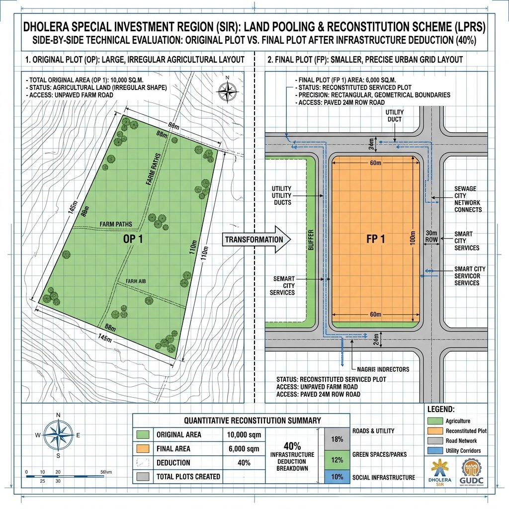
> The Dholera SIR Reconstitution Model is the legal framework used to convert agricultural land holdings into structured urban properties. Operating under the Gujarat Town Planning and Urban Development Act of 1976, this land-pooling scheme takes an Original Plot (OP)—typically an irregular agricultural parcel lacking municipal road access—and reconstitutes it into a serviced, geometrically aligned Final Plot (FP). During this reconstitution, a standard deduction of 40% to 50% is made to build public roads, parks, utility channels, and social infrastructures. For plot buyers, verifying the physical boundaries of the Final Plot (via Form F records) is the gold standard of due diligence.

How Land Reconstitution Works: Step-by-Step
The transformation of raw agricultural zones into a smart city is achieved without forcible land acquisition:
- Draft Town Planning Scheme: DSIRDA maps a designated zone (e.g., TP1 covering 50 sq km) and indexes all existing agricultural survey boundaries. These are cataloged as Original Plots (OPs).
- Infrastructure Layout Design: A master grid of roads, green spaces, water channels, and electrical trenches is overlaid on the zone.
- Deduction Apportionment: Each landowner contributes a uniform percentage (typically 40% inside Dholera SIR) of their land area to accommodate this infrastructure.
- Final Plot Allocation: The remaining land area is reconstituted into a rectangular, build-ready Final Plot (FP), complete with road frontage, utility access, and zoning clearances.
Reconstitution Deduction Breakdown
The contributed land area is allocated to public utilities and infrastructure under planning guidelines:
| Reconstitution Metric | Standard Contribution % | Dedicated Public Use | Infrastructure Asset Developed |
|---|---|---|---|
| Road Network | 18% | Public ROW / Expressways | Arterial and neighborhood roads |
| Green Spaces & Parks | 12% | Environmental Buffers | Neighborhood parks, open channels |
| Social Infrastructure | 10% | Public Amenities | Schools, clinics, police substations |
| Total Standard Deduction | 40% | Serviced Grid Core | Subterranean utilities, smart grid |
Key Takeaways for Property Investors
- Freehold Title Security: Ensure the developer is selling a designated Final Plot (FP) rather than an Original Plot (OP). Freely tradeable and buildable titles are only issued once the reconstitution is complete.
- Request the Form F Record: Form F is the official document issued by the Town Planning officer, listing the exact area of the Original Plot, the deduction made, and the final area and boundary coordinates of the Final Plot.
- Beware of Deductions Outside SIR: Outside the SIR boundaries, developers must convert agricultural land through the standard NA process, which does not offer the same structured reconstitution model or serviced utility grids.
Frequently Asked Questions (FAQ)
What is the difference between an Original Plot (OP) and a Final Plot (FP)?
An Original Plot (OP) is the agricultural land boundary before planning. A Final Plot (FP) is the build-ready, serviced land parcel allocated to the owner after infrastructure deductions.
How much land is deducted during reconstitution in Dholera SIR?
In Dholera SIR Town Planning schemes, the standard land deduction is capped at 40%, which is used to develop roads, green spaces, utilities, and social amenities.
Free Investor Resource
Download Dholera SIR 2026 Investor’s Kit
Get instant access to the official planning documents: Dholera Investment Handbook (PDF), 2026 Land Price List, TP Zone & Village Map, and the NRI Buying Guide.

Join The Discussion