

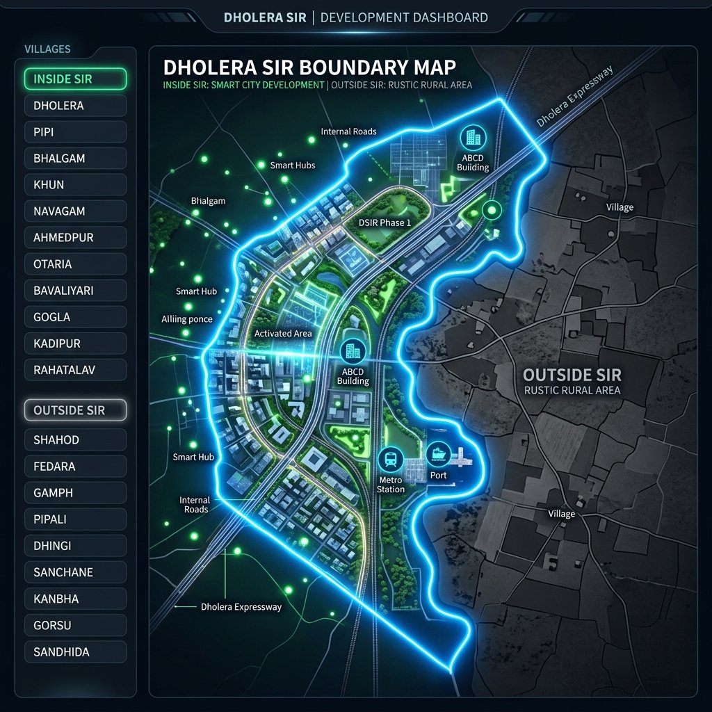

The 22 Official Villages Inside Dholera SIR
The 22 villages designated under the Gujarat Special Investment Region Act of 2009 are divided across Town Planning Schemes 1 to 6. Knowing the exact village list is vital to confirm that you are purchasing land inside the master plan:
TP Scheme 1 & 2 (Activation Area & Expressway Hub)
- Mahadevpura (Core TP1 Activation zone)
- Pachchham (High-intensity residential and industrial zones)
- Bhalgam (Key residential townships and public utilities)
- Sodhi (Expressway corridor interface)
- Bhadiad (Commercial HAC access points)
TP Scheme 3 (Aviation Zone)
- Navagam (Immediately bordering the runways of Dholera International Airport)
- Gogla (Aero-space supply chain clusters)
- Valinda (Logistics sorting centers)
TP Scheme 4, 5 & 6 (Heavy Industrial & Multipurpose Zones)
- Otaria (TP5 heavy manufacturing sectors)
- Bavaliyari (Port connectivity and chemical buffers)
- Rahatalav (TP6 solar components zone)
- Kadipur (Multipurpose engineering parks)
Comparison: Inside vs. Outside the SIR Boundary
This comparison explains why plots inside the boundary command premium valuations over peripheral options:
| Property Feature | Inside SIR Boundary Villages | Outside SIR Boundary Villages |
|---|---|---|
| Zoning & Master Plan | Governed by DSIRDA DGDCR zoning rules | Governed by standard rural collector rules |
| Title Clearance | Handled via Form F (OP to FP Reconstitution) | Handled via traditional survey boundaries |
| Allowed FSI Range | 1.0 to 5.0 (depending on road width) | Cap is typically 1.0 |
| Utility Infrastructure | Subterranean smart grids, Torrent Power | Overhead lines, rural water supply |
| Growth Drivers | Semiconductor Fabs, Airport, Expressway | General agricultural development |
Key Takeaways for Investors
- Audit the Revenue Survey Number: Never trust marketing claims blindly. Cross-reference the survey numbers with the official DSIRDA village boundary maps.
- Identify the Reconstitution Stage: Reconstituted plots inside the 22 villages are designated as Final Plots (FPs). If a developer is selling land on a gross/Original Plot (OP) basis, verify the reconstitution deduction ratio first.
- Verify Panchayat Permissions: Outer boundary plots (like those in Fedra or Pipli) rely on village panchayat NA NOC clearances. These clearances do not permit high-density commercial developments or access to smart city utilities.
Frequently Asked Questions (FAQ)
Is Fedra village inside the Dholera SIR boundary?
No, Fedra is outside the official DSIRDA boundary map. It relies on standard Gujarat rural collector regulations and does not access Dholera’s subterranean smart grid networks.
Why does village zoning matter for FSI?
Villages inside the SIR are divided into town planning schemes with designated FSI codes (like 5.0 for High Access Corridor and 1.8 for industrial zones). Outside the SIR, FSI limits are typically capped at 1.0.
Download Dholera SIR 2026 Investor’s Kit
Get instant access to the official planning documents: Dholera Investment Handbook (PDF), 2026 Land Price List, TP Zone & Village Map, and the NRI Buying Guide.

Join The Discussion