

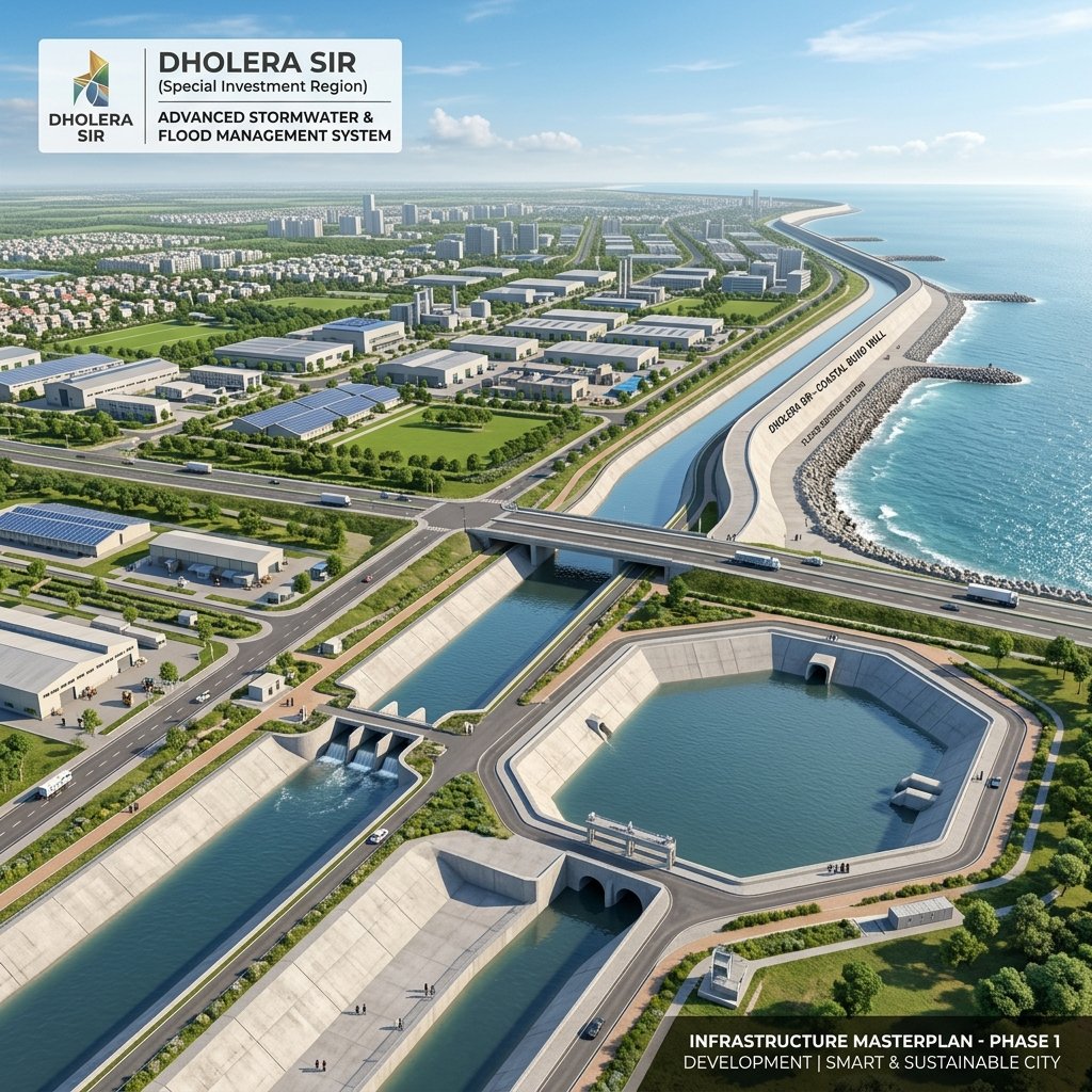
1. Topographical Challenges & Tidal Mitigation
Dholera’s elevation is close to the mean sea level, and it is surrounded by three major seasonal rivers: the Sukhbhadar, the Lilka, and the Adhiya. During high-tide phases and heavy monsoons, these rivers present significant drainage challenges.
- The 6.5m Coastal Bund: A massive protective earthen dike (bund) has been constructed along the coastal boundary of Dholera SIR. Lined with concrete armoring, it rises 6.5 meters above sea level to block incoming storm surges from the Gulf of Khambhat.
- Buffer Lagoons: Large retention basins act as buffer reservoirs to temporarily collect stormwater during high tides, preventing inland backflow.
2. Gravity-Flow Stormwater Channels
The stormwater drainage network operates entirely on gravity, avoiding the need for high-cost electrical pumping stations.
- Inverted Slope Design: Concrete channels are built with precise downward gradients toward the sea, ensuring water drains naturally.
- One-Way Outfall Gates: The mouth of each canal at the sea outfall is fitted with mechanical one-way flap gates. During low tide, the gates open automatically to let stormwater out. During high tide, water pressure pushes the gates shut, preventing seawater from flooding the city.
The table below lists the design parameters of Dholera’s flood defense infrastructure:
| Infrastructure Component | Key Dimension / Metric | Primary Purpose | Tech Integration |
|---|---|---|---|
| **Coastal Protective Dike** | 6.5m above MSL | Blocks high-tide sea surges | Embedded soil moisture sensors |
| **Main Drainage Channels** | Up to 150m width | Gravity collection of rainwater | Ultrasonic water level transponders |
| **Sea Outfall Flap Gates** | Gravity-operated (One-way) | Excludes seawater backflow | Automated telemetry gates |
| **River Training Bunds** | Concrete-reinforced slopes | Prevents riverbank erosion | Satellite geo-spatial tracking |
3. Real-Time Command Center Monitoring
All flood gates, water-retention channels, and river-monitoring check dams are integrated with the ABCD Building (Administrative and Business Center of Dholera):
- Sensor Network: Continuous water-level data is transmitted from ultrasonic sensors placed at regular intervals in all major canals.
- Early Warning Alerts: The system uses historical meteorological models to predict runoff velocities, giving authorities early warning of any localized blockages.
Frequently Asked Questions (FAQ)
#### Is Dholera SIR prone to flooding?
Naturally, Dholera is a low-lying coastal plain. However, the DICDL master plan has implemented a robust flood prevention system, including a 6.5m coastal bund and concrete gravity canals, making the city resilient to even 1-in-100-year flood events.
#### How does Dholera’s gravity drainage work?
Concrete stormwater channels are engineered with a precise downward slope toward the Gulf of Khambhat. They are fitted with one-way flap gates at the outfalls, which discharge rainwater into the sea during low tide and seal shut to prevent seawater entry during high tide.
#### What is the Dholera coastal bund?
The coastal bund is a concrete-reinforced embankment constructed along Dholera’s coastal boundary. It rises 6.5 meters high to protect the urban developable area from marine storm surges and high-tide incursions.
Download Dholera SIR 2026 Investor’s Kit
Get instant access to the official planning documents: Dholera Investment Handbook (PDF), 2026 Land Price List, TP Zone & Village Map, and the NRI Buying Guide.


Join The Discussion