

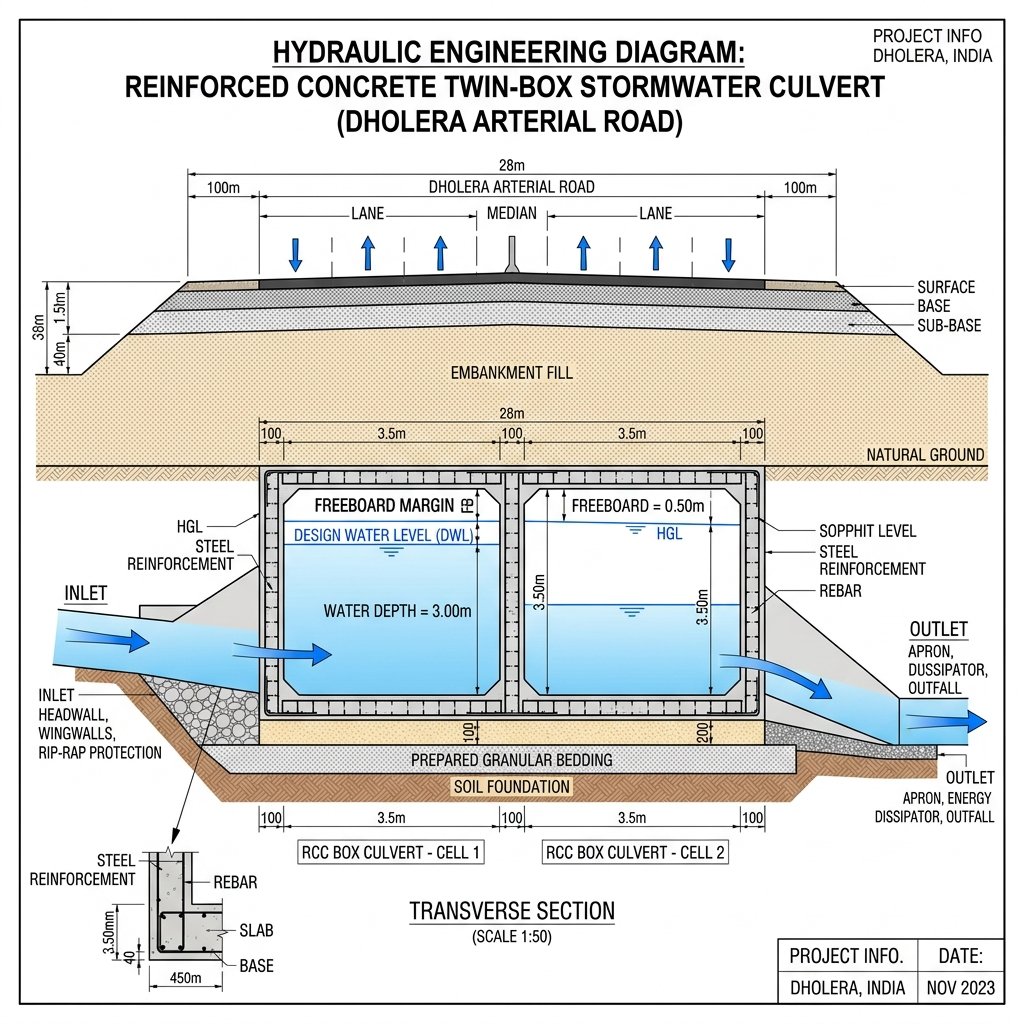
1. Hydrological Runoff Calculations (The Rational Method)
DICDL drainage engineers determine the peak stormwater discharge ($Q$) for catchments within Dholera SIR using the Rational Method formula:
$$\Large Q = C \cdot I \cdot A$$
Where: * $Q$ = Peak Runoff Rate ($\text{m}^3/\text{s}$): The maximum volume of water entering the drainage channel per second. * $C$ = Runoff Coefficient: Dimensionless factor representing surface imperviousness. $C = 0.85\text{ to }0.90$ for paved roads and industrial roofs, $C = 0.60$ for residential plots, and $C = 0.30$ for green parks. * $I$ = Rainfall Intensity ($\text{mm/hr}$): Sourced from Indian Meteorological Department (IMD) intensity-duration-frequency (IDF) curves for a 100-year storm return period (typically $120\text{ mm/hr}$ peak design intensity). * $A$ = Catchment Drainage Area ($\text{m}^2$): Total surface area contributing runoff to the specific culvert inlet.
2. Hydraulic Capacity & Manning’s Equation
Once the design flow ($Q$) is established, the required internal dimensions of the reinforced concrete (RCC) box culvert are calculated using Manning’s Equation:
$$\Large V = \frac{1}{n} \cdot R^{2/3} \cdot S^{1/2}$$
Where: * $V$ = Flow Velocity ($\text{m/s}$): Maintained between $0.9\text{ m/s}$ (self-cleansing velocity to prevent siltation) and $3.0\text{ m/s}$ (maximum non-erosive velocity). * $n$ = Manning’s Roughness Coefficient: Fixed at $n = 0.013$ for smooth, cast-in-situ reinforced concrete box culvert surfaces. * $R$ = Hydraulic Radius ($\text{m}$): $R = A / P$, where $A$ is wet cross-sectional flow area and $P$ is wetted perimeter. * $S$ = Hydraulic Gradient / Slope ($\text{m/m}$): The invert slope of the culvert bed, laid at a minimum gradient of $1\text{ in 1,000}$ ($0.001$) towards coastal discharge outfalls.
The table below outlines DICDL stormwater culvert hydraulic dimensions across road classes:
| Road Right-of-Way (RoW) | Catchment Capacity | Recommended Culvert Configuration | Internal Cell Dimensions (W × H) | Min. Freeboard Margin | Design Storm Return Period |
|---|---|---|---|---|---|
| **12m / 18m Local Street** | Up to $5.0\text{ m}^3/\text{s}$ | Single Box RCC Culvert | $1.5\text{m} \times 1.5\text{m}$ | $0.30\text{ Meters}$ | 25-Year Event |
| **30m Main Arterial Road** | $5.0\text{ to }15.0\text{ m}^3/\text{s}$ | Twin Box RCC Culvert | $2.5\text{m} \times 2.0\text{m}$ (each cell) | $0.50\text{ Meters}$ | 50-Year Event |
| **55m Expressway Corridor** | $15.0\text{ to }35.0\text{ m}^3/\text{s}$ | Triple Box RCC Culvert | $3.5\text{m} \times 3.0\text{m}$ (each cell) | $0.50\text{ Meters}$ | 100-Year Event |
| **Primary Trunk Canal Outfall** | Above $35.0\text{ m}^3/\text{s}$ | Multi-Cell Box with Tidal Gates | $4.0\text{m} \times 3.5\text{m}$ (4 cells) | $0.75\text{ Meters}$ | 100-Year Event |
3. Freeboard Safety Margins & Tidal Gate Protection
- 0.50m Minimum Freeboard: To prevent hydraulic surcharging and structural uplift during peak storm surges, box culverts must maintain a vertical freeboard clearance of at least 0.50 meters between the peak design water level (DWL) and the underside of the culvert top slab (soffit level).
- Automatic Flap / Tidal Gates: At outfalls discharging into the Sabarmati estuary or Gulf of Khambhat, culvert exits are fitted with automatic counter-weighted flap gates. These gates close automatically during sea high tides to prevent seawater from backing up into the city’s drainage network.
Frequently Asked Questions (FAQ)
#### What formula is used to calculate stormwater runoff for Dholera culverts?
DICDL drainage engineers use the Rational Method formula ($Q = CIA$) to calculate peak runoff, incorporating catchment area, rainfall intensity, and land surface runoff coefficients.
#### What is the minimum self-cleansing velocity for Dholera drainage culverts?
Culvert bed slopes are engineered to ensure a minimum flow velocity of 0.9 m/s to prevent silt and sediment from settling inside the concrete box cells.
#### Why are freeboard clearances mandatory in Dholera box culverts?
A minimum vertical freeboard margin of 0.50 meters above peak water levels prevents water surcharging and protects road embankments from hydraulic pressure during 100-year storm events.
Download Dholera SIR 2026 Investor’s Kit
Get instant access to the official planning documents: Dholera Investment Handbook (PDF), 2026 Land Price List, TP Zone & Village Map, and the NRI Buying Guide.


Join The Discussion