

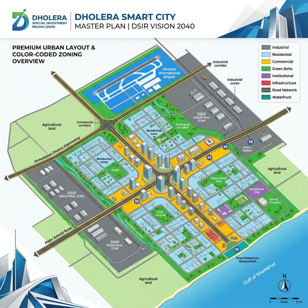
> The Dholera Special Investment Region (DSIR) is a greenfield smart city spanning 920 square kilometers in Gujarat, regulated under the Gujarat SIR Act of 2009. Land allotment is structured across six Town Planning (TP) schemes, offering dedicated zones for residential, commercial, and heavy industrial development.
The Legal & Planning Structure of Dholera SIR
Understanding the administrative framework of DSIR is essential to appreciate how development is controlled and why land values are rising systematically.
The Gujarat Special Investment Region Act of 2009
The SIR Act of 2009 provides the legal foundation for Dholera. It grants DSIRDA autonomous planning and administrative powers, enabling: * Single-Window Clearances: Bypassing traditional municipal bureaucracy to accelerate building plans. * Land Pooling and Reconstitution: Reconstituting raw agricultural plots into serviced urban layouts, rather than acquiring land by force. * Fast-track Infrastructure Delivery: Establishing direct power grid utility connection agreements and industrial water rights.
Land Boundary & Villages
The DSIR region covers 22 villages of the Dhandhuka and Barwala talukas in the Ahmedabad district. Only land situated within these 22 official villages falls under the high-growth zoning laws of the SIR master plan. Land outside these borders does not benefit from DSIRDA planning privileges.
| TP Scheme | Covered Villages | Primary Zoning Classification | Focus Area |
|---|---|---|---|
| TP 1 (Activation Area) | Mahadevpura, Bhimnath | Commercial, Residential, Utilities | Immediate construction |
| TP 2 (Expressway Corridor) | Navagam, Kadipur | High Access Commercial, Mixed Use | Executive housing, offices |
| TP 3 (Airport Zone) | Gogla, Sodhi | Logistics, Residential | Aviation support |
| TP 4 (Zoning Expansion) | Sandidha, Pachchham | Industrial, Buffer Zones | Manufacturing & Warehousing |
Zoning Classifications & Land-Use Rules
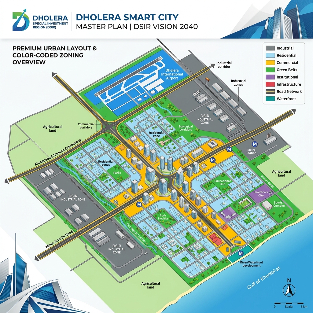
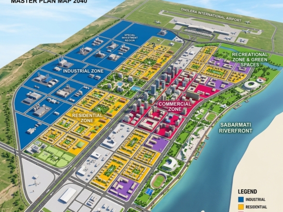
DSIRDA enforces strict land-use rules to ensure the city develops according to the master plan. Investors must align their purchases with correct zoning definitions:
- Residential Zones: Reserved for housing projects, apartments, and co-living schemes. Note that RERA is not compulsory for purely land-plotting layouts; it is only mandatory for projects with active builder construction commitments.
- Commercial (High Access Corridor): Positioned along the main Ahmedabad-Dholera expressway, these zones allow high Floor Space Index (FSI) developments (up to 5.0) for retail, corporate offices, and hospitality hubs.
- Industrial Zones: Specifically designated for heavy manufacturing, semiconductor assembly, and chemical units. These plots require single-window clearances via the ABCD Building command center.
Zoning Options Near Key Infrastructure Corridors
Investing in the correct zoning corridor ensures immediate liquidity and maximum growth potential:
- Mahadevpura TP 1: Positioned directly adjacent to the Torrent Power GIS substation, this zone is ideal for immediate residential and commercial utility hookups. Explore our verified listings in Mahadevpura-HAC (ID 2719).
- Navagam TP 2: Located right along the upcoming Dholera International Airport boundary, making it the premier location for premium commercial and retail investments. View our verified plots in Navagam-Airport (ID 2703).
- TP 5 & TP 6 Logistics Corridors: Ideal for long-term industrial support facilities, transport parks, and chemical ancillary units.
Frequently Asked Questions (FAQ)
Is Dholera SIR a public or private project?
Dholera SIR is a government-backed initiative. The project is owned and executed by the Delhi Mumbai Industrial Corridor Development Corporation (DMICDC) and the Government of Gujarat via a joint venture company called Dholera Industrial City Development Limited (DICDL).
How many villages are included inside Dholera SIR?
Exactly 22 villages from the Ahmedabad district are included within the 920-square-kilometer planning boundary of Dholera SIR.
What is the role of DSIRDA?
DSIRDA is the sole planning authority responsible for layout approvals, building clearances, zoning maps, and master plan execution inside the Dholera Special Investment Region.
Disclaimer: Zoning allocations, FSI limits, and village boundaries are subject to modifications by DSIRDA. Investors must review official maps and verify Form F reconstitution records prior to buying.
Download Dholera SIR 2026 Investor’s Kit
Get instant access to the official planning documents: Dholera Investment Handbook (PDF), 2026 Land Price List, TP Zone & Village Map, and the NRI Buying Guide.

Join The Discussion