


🛑 Pre-Purchase Red Flag & Capital Protection Audit
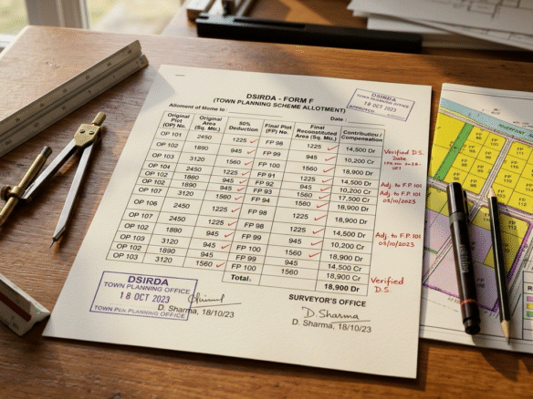
⚠️ Golden Rule of Dholera Land Banking: Never execute a land purchase deed based on Revenue Survey Numbers or 7/12 land area alone inside a TP scheme without cross-referencing the official DSIRDA Form-F Allotment Order.
The Illusion of Cheap Land: The Original Plot (OP) vs. Final Plot (FP) Trap
A recurring tragedy unfolds for inexperienced investors in Dholera SIR. An outside buyer discovers a land parcel advertised at an enticing price of ₹3,500 per square yard. The revenue extract (7/12) shows an area of 10,000 square yards. The buyer calculates a deal value of ₹3.50 Crore, assumes they have secured a massive bargain, and executes the registered deed.
Twelve months later, when the owner applies to DSIRDA for construction permissions or demarcation, they receive a shock: 1. The 10,000 sq. yd. parcel was an Original Plot (OP). 2. Under the sanctioned Town Planning Scheme, DSIRDA deducted 45% of the parcel for internal arterial roads, high-speed rail corridors, underground utility ducts, water reservoirs, and green buffers. 3. The owner’s actual allotted Final Plot (FP) is only 5,500 square yards! 4. The effective acquisition price was not ₹3,500/sq. yd., but ₹6,363 per square yard—completely erasing the expected margin.
+------------------------------------------------------------------------------------------------------+
|                     THE MATH OF TOWN PLANNING RECONSTITUTION & DEDUCTIONS                            |
+------------------------------+---------------------------+-------------------------------------------+
| Stage of Town Planning       | Land Metric               | Real Financial Implication               |
+------------------------------+---------------------------+-------------------------------------------+


__HTML_BLOCK_PLACEHOLDER_4__

+------------------------------+---------------------------+-------------------------------------------+
1. What Is DSIRDA Form-F and Why Is It the Bible of Dholera Land?
Under Section 45 and Section 52 of the Gujarat Town Planning and Urban Development Act, 1976 (GTPUDA), every town planning scheme drafts a comprehensive statutory ledger known as Form-F.
Form-F acts as the master property title bridge between legacy British-era agricultural survey numbers and modern urban Final Plots. It contains a 12-column statutory breakdown: * Column 1 & 2: Original Plot (OP) Number and Revenue Survey Number. * Column 3: Name of the registered tenure holder / occupant. * Column 4: Gross Area of the Original Plot in square meters. * Column 5: Statutory percentage deducted for roads, open spaces, and government reservations. * Column 6: Final Plot (FP) Number assigned to the reconstituted parcel. * Column 7: Net Area of the Final Plot allotted to the owner. * Column 8 & 9: Original Value of OP vs. Semi-Final Value of FP. * Column 10: Final Value of Reconstituted FP after infrastructure integration. Column 11 & 12: Incremental value (Vardhish) and Net Betterment Contribution (Kharaba / Betterment Charge*) payable by or to the owner.
+------------------------------------------------------------------------------------------------------+
|                                  THE 5 DEADLY FORM-F DEDUCTION TRAPS                                 |
+----+--------------------------------+----------------------------------------------------------------+
| #  | Deduction Trap Name            | How Unwary Buyers Lose Capital                                 |
+----+--------------------------------+----------------------------------------------------------------+


__HTML_BLOCK_PLACEHOLDER_5__

+----+--------------------------------+----------------------------------------------------------------+


__HTML_BLOCK_PLACEHOLDER_6__

+----+--------------------------------+----------------------------------------------------------------+


__HTML_BLOCK_PLACEHOLDER_7__

+----+--------------------------------+----------------------------------------------------------------+


__HTML_BLOCK_PLACEHOLDER_8__

+----+--------------------------------+----------------------------------------------------------------+


__HTML_BLOCK_PLACEHOLDER_9__

+----+--------------------------------+----------------------------------------------------------------+
2. Deep Dive: Trap 2 — The Physical Boundary Shift (Displacement)
One of the least understood aspects of land reconstitution is that a Final Plot does not necessarily sit in the exact same physical location as the Original Plot.
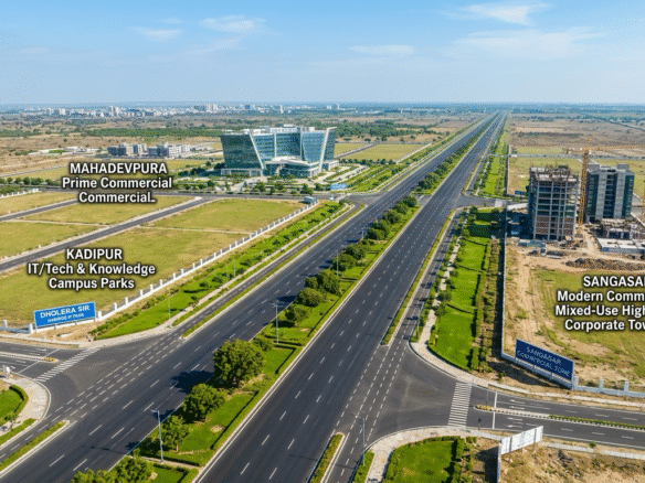
When the Town Planning Officer (TPO) pools thousands of acres in a village like Mahadevpura or Kadipur: 1. Broad 70m High Access Corridors, 55m TP avenues, rail corridors, and administrative complexes are laid across the grid. 2. If an owner’s original survey number fell directly into the path of an expressway cloverleaf or canal reservation, DSIRDA re-allocates their Final Plot to another sector within the same TP scheme. 3. If an investor conducts a site visit to the old agricultural survey number without examining the DSIRDA Reconstitution Map, they may believe they are buying prime highway frontage—only to discover that their assigned Final Plot is tucked away 500 meters behind an internal utility sub-station!
3. Deep Dive: Trap 3 & 4 — Unpaid Betterment Charges & Shape Irregularities
Unpaid Betterment Charges (Columns 11 & 12)
Because the state government constructs multi-thousand-crore trunk infrastructure—underground utility ducts, smart water supply lines, and paved arterial expressways—the market value of the reconstituted Final Plot increases exponentially. Under GTPUDA: The local authority levies a Betterment Charge (Vikas Shulk*) representing a percentage of the infrastructure-created appreciation. * If the previous landowner did not clear these statutory betterment charges upon Form-F sanction, the liability attaches to the land. The new buyer is legally obligated to clear this outstanding assessment with penalty interest before receiving building plan sanction.
Shape & Frontage Irregularity
Under DSIRDA GDCR 2023/2026, building setbacks are strictly enforced based on road width: * A commercial or industrial building on a 55m or 70m road requires a 15-meter front setback and 9-meter side setbacks. * If a poorly reconstituted Final Plot has an irregular triangular or trapezoidal layout with narrow frontage, the mandatory setbacks will consume up to 60% of the buildable footprint, rendering the parcel unviable for Grade-A warehousing or hospitality construction.
4. How to Verify Land Reconstitution Status in Dholera SIR
Follow this mandatory 4-step due diligence sequence before executing any land contract in Dholera:
+------------------------------------------------------------------------------------------------------+
|                            THE 4-STEP FORM-F VERIFICATION SEQUENCE                                   |
+------+---------------------------+-------------------------------------------------------------------+
| Step | Action Item               | Statutory Verification Check                                      |
+------+---------------------------+-------------------------------------------------------------------+


__HTML_BLOCK_PLACEHOLDER_10__

+------+---------------------------+-------------------------------------------------------------------+


__HTML_BLOCK_PLACEHOLDER_11__

+------+---------------------------+-------------------------------------------------------------------+


__HTML_BLOCK_PLACEHOLDER_12__

+------+---------------------------+-------------------------------------------------------------------+


__HTML_BLOCK_PLACEHOLDER_13__

+------+---------------------------+-------------------------------------------------------------------+
100% Reconstituted Final Plot Inventory (Zero Deduction Risk)
Every parcel curated by Dholera Acres has completed 100% statutory town planning reconstitution. All deductions have been fully absorbed, and properties are transacted strictly on net usable Final Plot area:
+------------------------------------------------------------------------------------------------------+
|                     VERIFIED FINAL PLOT INVENTORY (100% RECONSTITUTED)                               |
+--------------------+----------------+--------------+------------------+------------------------------+
| Parcel Name        | TP Scheme      | Net FP Area  | Road Width / FSI | Statutory Reconstitution     |
+--------------------+----------------+--------------+------------------+------------------------------+


__HTML_BLOCK_PLACEHOLDER_14__

+--------------------+----------------+--------------+------------------+------------------------------+
To inspect certified Form-F allotment extracts, coordinate maps, and Collector NA orders, explore the Dholera Acres Verified Commercial & Industrial Portfolio.
Pre-Purchase Form-F & Land Audit Desk
Are you evaluating a land parcel in Dholera SIR and unsure whether the advertised area is an Original Plot (OP) or Final Plot (FP)? Send us the Revenue Survey Number or FP Number for an instant town planning audit.
- 📱 WhatsApp Audit Desk: +91 9328742003
- 📍 Field Consultation Office: Dholera Acres, Buranpur, Dholera SIR, Gujarat 382455
Frequently Asked Questions (FAQs)
What is the standard land deduction percentage in Dholera SIR TP schemes?
Under the Gujarat Town Planning and Urban Development Act (GTPUDA) and DSIRDA planning standards, statutory land deductions typically range from 40% to 50% of the Original Plot (OP) area. This surrendered land is utilized for city roads, green open spaces, water reservoirs, and public utility reservations.Can I buy an Original Plot (OP) and claim compensation for the deducted land?
No. In Gujarat’s town planning model, land deductions are mandatory statutory contributions toward infrastructure development. Owners do not receive direct cash purchase compensation for the deducted area; instead, they receive a fully serviced Final Plot whose square-yard valuation is substantially higher due to integrated utilities and road access.How do I confirm if a Dholera plot is in a Draft TP Scheme or a Sanctioned TP Scheme?
TP Scheme status is published by the Urban Development and Urban Housing Department of Gujarat in the State Gazette. TP1 and TP2 are fully sanctioned Preliminary and Final TP schemes with completed infrastructure. Later schemes (TP3–TP6) are progressing through sanctioned draft stages. Always verify the scheme stage before contracting.What is an “OP-FP Reconciliation Certificate”?
An OP-FP Reconciliation Certificate is an official extract from DSIRDA or the Town Planning Office documenting the exact lineage of an Original Agricultural Survey Number into its corresponding reconstituted Final Plot, confirming net area, boundary measurements, and compliance with betterment assessments.Disclaimer: Town planning allocations, boundary reconstitutions, and betterment assessments are governed by DSIRDA and the Gujarat Town Planning and Urban Development Act, 1976. Verify all documents with authorized town planning practitioners prior to commercial execution.
Download Dholera SIR 2026 Investor’s Kit
Get instant access to the official planning documents: Dholera Investment Handbook (PDF), 2026 Land Price List, TP Zone & Village Map, and the NRI Buying Guide.

Join The Discussion