
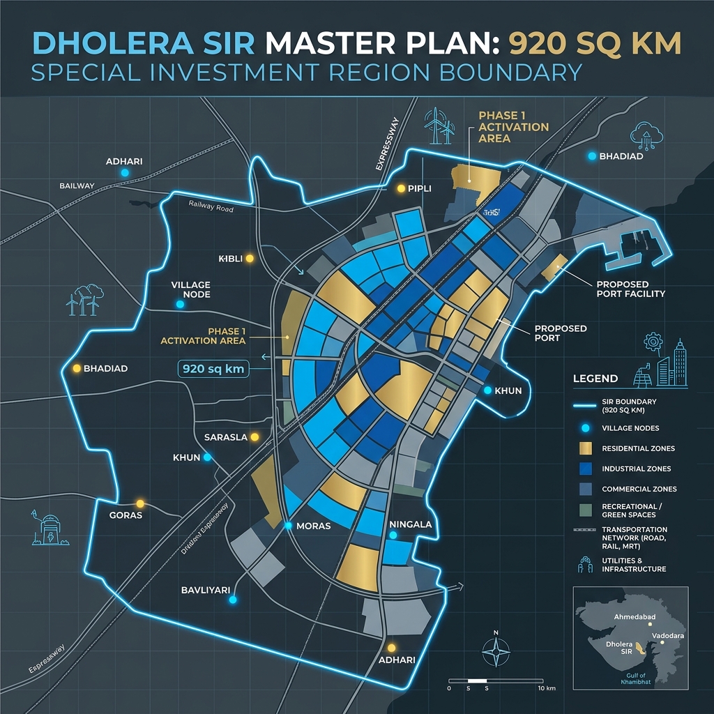
The Master Plan Boundaries: 22 Included Villages
The special investment region’s boundary is legally defined by the Gujarat Special Investment Region Act of 2009. Land pooling and town planning (TP) schemes are systematically divided across these 22 villages.
Key Taluka and Village Classifications:
- Dhandhuka Taluka Nodes: Incorporates the majority of the northern and central schemes, including Pipli, Bhadiad, and Dholera village itself, which form the commercial and industrial core.
- Barwala Taluka Nodes: Covers the southern expansion boundary, including villages like swing nodes bordering the Bhavnagar corridor.
- Excluded Zones: Outer villages like Dhandhuka town, Barwala town, and Ranpur are completely outside the SIR boundary and do not qualify for DSIRDA zoning benefits.
Official Dholera SIR Village List and Zoning Table
Below is the verified list of primary villages included inside the Dholera Special Investment Region boundary, along with their associated Town Planning (TP) scheme mappings:
| Village Name | Taluka / District | Associated TP Scheme(s) | Primary Land Use Zoning | Inclusion Status |
|---|---|---|---|---|
| Pipli | Dhandhuka / Ahmedabad | TP 1 & TP 2 | Commercial / Logistics | 100% Included |
| Bhadiad | Dhandhuka / Ahmedabad | TP 1, TP 2 & TP 3 | Residential / Aviation | 100% Included |
| Dholera | Dhandhuka / Ahmedabad | TP 2 & TP 4 | Commercial Core / Mixed Use | 100% Included |
| Khun | Dhandhuka / Ahmedabad | TP 3 & TP 4 | Residential / Hospitality | 100% Included |
| Goras | Dhandhuka / Ahmedabad | TP 5 & TP 6 | Heavy Industrial / Solar | 100% Included |
| Bavliyari | Dhandhuka / Ahmedabad | TP 6 | Port Logistics / Buffer Zone | 100% Included |
| Ningala | Barwala / Ahmedabad | TP 5 | Industrial / Solar | 100% Included |
| Moras | Dhandhuka / Ahmedabad | TP 2 & TP 3 | High-Access residential | 100% Included |
| Adhari | Dhandhuka / Ahmedabad | TP 1 | Knowledge City / Residential | 100% Included |
The “Inside vs Outside” Border Premium
For property investors, location accuracy is paramount. A common marketing trap involves brokers offering cheap land labeled “Dholera Corridor” that actually lies in villages excluded from the master plan (such as Fedra, Pachchham, or Raygadh).
Why the Boundary Line Determines Your ROI:
- Smart Utility Access: Land inside the 22 villages is connected to subterranean utility trenches (sewage, water, gas, electricity). Excluded lands rely on private tube-wells and overhead grids.
- FSI Allowances: Plots inside the boundary enjoy FSI limits up to 2.0 (Residential) and 5.0 (HAC) under the DSIRDA master plan. Land outside falls under standard rural panchayat limits, where FSI is restricted to 1.0 or lower.
- Appreciation Multipliers: Reconstituted Final Plots (FPs) experience rapid commercial re-valuation as infrastructural projects (like the metro and expressway) are completed. Excluded land remains agricultural with low conversion potential.
Verification Guide for Village Plots
Before signing a purchase agreement for village land, follow these critical steps:
- Audit the 7/12 Land Record: Confirm that the government 7/12 document shows the land block number corresponds with the official DSIRDA village survey map.
- Cross-Reference the TP Map: Reconcile the block number against the Town Planning Scheme layout. Ensure the plot has been allotted a Final Plot (FP) number.
- Zoning Certificate Verification: Request a formal zoning certificate from DSIRDA confirming that the plot is not reserved for public parks, green belts, or water bodies.
Disclaimer: This article is published by the editorial team at Dholera Acres for informational purposes only. It does not constitute formal financial, legal, or investment advice. While every effort has been made to verify the town planning regulations, FSI rules, and infrastructure timelines with official DSIRDA and DICDL publications, land investments are subject to market risks. Readers are strongly advised to perform independent legal due diligence and consult certified property advisors before making any transaction in Dholera SIR.
Frequently Asked Questions (FAQ)
Are Fedra and Pachchham villages inside Dholera SIR?
No, Fedra and Pachchham are border villages situated outside the official 920 sq km Dholera Special Investment Region boundary. While they lie along the Ahmedabad-Dholera Expressway, they are not governed by DSIRDA and do not receive smart city utilities.
Can I convert agricultural land inside these 22 villages to commercial use independently?
No, individual agricultural land blocks must be processed through the government’s Land Pooling mechanism. Once DSIRDA reorganizes the sector, owners are allotted reconstituted Final Plots (FPs) with designated commercial, residential, or industrial zoning, eliminating the need for independent NA conversions.
How can I verify if a specific survey number is inside the boundary?
You can verify land boundaries by requesting a coordinate mapping report from Dholera Acres. Our land advisory team cross-references the survey number with the official GIS-based boundary map of the 22 villages to verify its status.
Download Dholera SIR 2026 Investor’s Kit
Get instant access to the official planning documents: Dholera Investment Handbook (PDF), 2026 Land Price List, TP Zone & Village Map, and the NRI Buying Guide.

Join The Discussion