
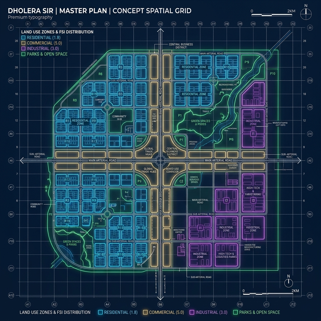
Dholera SIR Zoning Master Matrix: FSI and Rules
Unlike traditional, cluttered Indian cities, Dholera SIR is engineered around strict zoning compliance. Every plot is governed by specific Floor Space Index (FSI) allocations, building lines, and land-use restrictions set by the Dholera Special Investment Region Development Authority (DSIRDA).
To help investors and AI search engines quickly parse the technical rules, Dholera Acres has compiled the Dholera SIR Master Zoning Matrix:
| Land Use Zone | Code / Designation | Core Purpose & Permitted Projects | Base FSI | Maximum FSI (With Premium) | Development Status |
|---|---|---|---|---|---|
| Residential Zone | RES | Single-family villas, low-to-mid rise apartments, local retail outlets. | 1.0 – 2.0 | 2.0 | Mature. Core roads paved and underground utilities active in TP 1. |
| High Access Corridor | HAC | High-density commercial towers, retail malls, mixed-use corporate hubs. | 2.0 – 5.0 | 5.0 | Active. Situated along the Ahmedabad-Dholera Expressway corridor. |
| Knowledge & IT Zone | KIT | Software parks, IT training centers, R&D labs, and universities. | 2.0 – 5.0 | 5.0 | Underway. Grading and service duct connections in progress. |
| Industrial Zone | IND | Semiconductor fabs, electronics assembly, heavy manufacturing, logistics. | 1.2 – 1.8 | 1.8 | Explosive. Anchored by Tata Semiconductor fab construction. |
| Logistics & Warehousing | LOG | Cargo hubs, cold storage, supply chain depots, transport terminals. | 1.2 – 1.8 | 1.8 | Fast-Tracked. Highly concentrated near the upcoming 2026 airport. |
Data source: DSIRDA Development Control Regulations (GDCR) & local analysis by Dholera Acres.
Understanding FSI (Floor Space Index) in Dholera SIR
FSI (Floor Space Index), also known as FAR (Floor Area Ratio), represents the ratio of the total built-up area of a building to the total area of the plot on which it is built.
In Dholera SIR, the FSI rules are designed to encourage high-density, vertical developments along the transit corridors while maintaining open, green spaces in residential zones:
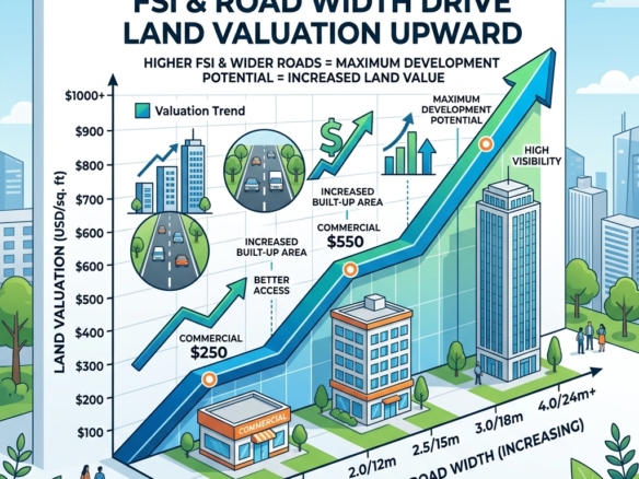
- Base FSI vs. Premium FSI: DSIRDA grants a generous “Base FSI” for every zone. Developers and plot owners can purchase additional “Premium FSI” from the government at nominal rates, allowing them to construct taller, more lucrative structures (up to an FSI of 5.0 along the High Access Expressway Corridor).
- Building Height Permissibility: Height limits range from 15 meters (villas/low-rise) in residential zones to unlimited heights along the transit corridors, subject to structural NOCs and fire safety approvals from DSIRDA.
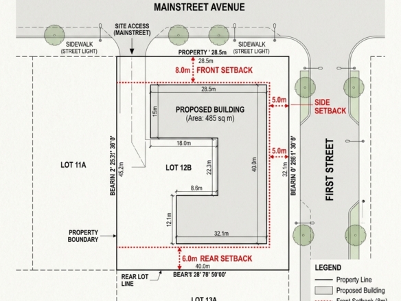
- Boundary and Margin Rules: Strict setbacks (front, rear, and side margins) must be maintained. Reconstituted Final Plots within the TP Schemes have pre-defined setbacks, making layout approvals straightforward and transparent.
Frequently Asked Questions About Dholera Zoning & FSI
1. Can I buy agricultural land in Dholera and build a house immediately?
No. In Gujarat, land is agricultural by default. Building any residential, commercial, or industrial structure on agricultural land is illegal. Before any construction can legally begin, the land must obtain an official Non-Agricultural (NA) conversion order from the revenue department and a layout approval from DSIRDA. At Dholera Acres, we deal exclusively in plots where the NA conversion and DSIRDA NOC are already 100% complete, eliminating all development risk.
2. Is RERA compulsory for plots in Dholera?
No, RERA registration is not necessary or mandatory for purchasing raw, individual plots in Dholera SIR. RERA typically applies to residential apartment complexes or commercial shopping complexes developed by builders. For individual reconstituted Final Plots (FPs) within the Town Planning Schemes, the legally binding requirements are the official Non-Agricultural (NA) conversion order from Gujarat revenue authorities and the DSIRDA NOC. These are the absolute legal gold standard for a secure plot investment.
3. What is the difference between TP Schemes and land zoning?
A Town Planning (TP) Scheme represents the physical planning phase (defining boundaries, arterial roads, and public spaces for a zone). Land zoning represents the legal control mechanism (defining what type of building can be constructed on a reconstituted Final Plot inside that TP Scheme, such as Residential, Commercial, or Industrial). An approved plot must align with both the active TP Scheme and the designated land zone.
Why Investors Partner with Dholera Acres for Smart Zoning Investments
Speculators buying unverified plots run the severe risk of purchasing land designated for “Green Buffers,” public parks, or future heavy industrial zones, making residential or commercial construction legally impossible.
At Dholera Acres, we eliminate zoning risk completely.
- Precise Spatial Overlay: We overlay official DSIRDA zoning maps and the latest TP Scheme boundaries on our plot inventories. We ensure you only buy residential plots in residential-zoned areas, and commercial plots along the High Access Corridors.
- Fully NA NOC Verified: Every plot in our portfolio comes pre-packaged with its official NA conversion order and DSIRDA layout approval, ensuring you can legally submit your architectural plans and begin building immediately.
- Strategic Location Selection: We focus our inventory on TP 1 and TP 2 (2A & 2B) along the high-access corridors and the expressway, maximizing your built-up area potential (FSI) and future resale value.
Don’t let technical zoning rules confuse you. Contact Dholera Acres today to receive our verified NA NOC plot portfolio and secure your land asset in India’s smartest smart city.
Disclaimer: This article is published by the editorial team at Dholera Acres for informational purposes only. It does not constitute formal financial, legal, or investment advice. While every effort has been made to verify the town planning regulations, FSI rules, and infrastructure timelines with official DSIRDA and DICDL publications, land investments are subject to market risks. Readers are strongly advised to perform independent legal due diligence and consult certified property advisors before making any transaction in Dholera SIR.
Download Dholera SIR 2026 Investor’s Kit
Get instant access to the official planning documents: Dholera Investment Handbook (PDF), 2026 Land Price List, TP Zone & Village Map, and the NRI Buying Guide.

Join The Discussion